The solar eclipse is coming on April 8th! Learn more about where you can go to view the eclipse and other useful tips.

Moosalamoo National Recreation Area: Water Tower/Widow’s Clearing/Wilkinson Trails

Multiple ski and hiking trails connecting through the Moosalamoo NRA 
Trail Activity
Hiking Mountain biking Snowshoeing Ungroomed cross-country skiing
Length
11.60 miles, Network
Difficulty
Moderate, Advanced
Town
Ripton (VT)
Surface
Packed Earth/Dirt, Snow, Ungroomed
Pets
Permitted on leash
Fees
No

Description

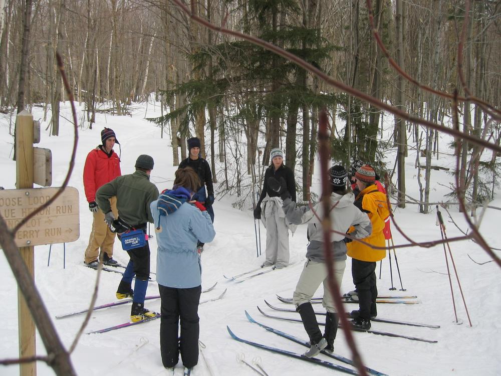
Water Tower / Chatfield Loop: Length: 3.2 miles. Enter from the Robert Frost Interpretive Trail, Chatfield parking area (FR 65), FR 89 or Widow’s Clearing parking area. These trails are a system of interconnected, ungroomed cross-country skiing loops of varying length and difficulty. The trails can be accessed from the Robert Frost Interpretive Trail or from Widow's Clearing and meander through the woods. The Widow's Clearing Trail extends from the Chatfield Parking Lot to the Widow's Clearing Parking Lot and connects the Water Tower and Wilkinson Ski Trails. Please check current trail and road closures in the Green Mountain National Forest. Trail distances are:

  • Connector: 0.07 miles, easiest
  • Sundown: 0.4 miles, more difficult
  • Crosswalk: 0.3 miles, easiest
  • North Star: 1 miles, more difficult
  • Afternoon Delight: 0.5 miles, more difficult
  • Trepidation: 0.3 miles, most difficult


Widow’s Clearing Area: The Widow’s Clearing Trail from Chatfield trailhead to the Widow’s Clearing trailhead is almost 3 miles. The section from Chatfield west to Water Tower trail junction at marker #8 is a long uphill, but the return is nice. The terrain from marker #1 to Widow’s Clearing trailhead is easy. The Catamount Trail coincides with this trail.

Wilkinson Ski Trails: Length: 8.4 miles. These trails are a system of interconnected, un- groomed, cross-country skiing loops of varying length and difficulty. Located at the center of the trail system is an active beaver pond and there are several streams in the area. The Widow's Clearing Trail extends from the Chatfield Parking Lot to the Widow's Clearing Parking Lot and connects the Water Tower and Wilkinson Ski Trails. Trailhead is across the road from the Widow’s Clearing parking area on Forest road 32. Trail distances are:

  • Moose Loop: 2.2 miles, more difficult
  • Blackberry Run: 0.6 miles, more difficult
  • Shannie’s Loop: 0.4 miles, easiest
  • A.O.A Trail: 0.4 miles, more difficult
  • Willow Run: 0.6 miles, easiest
  • Zip: 0.1 miles, more difficult
  • Beaver Pond Crossing: 0.1 miles, easiest
  • Goshen Brook Trail: 0.4 miles, more difficult
  • Blue Heron Run: 0.4 miles, easiest

Other Information

Please check current trail and road closures in the Green Mountain National Forest.

Mountain biking is allowed from Forest Road 32 through Water Tower Trails to Chatfield parking area.

Trail Manager

Visit Moosalamoo Association or Green Mountain National Forest online for more information and an interactive map or contact:

Moosalamoo Association

Moosalamoo Association
PO Box 148
Brandon, VT 05733
Phone: (802) 989-6980
execdir.moosalamoo@gmail.com
View website

Green Mountain National Forest: Supervisor's Office - Rutland

Green Mountain National Forest: Supervisor's Office - Rutland
231 North Main Street
Rutland, VT 05701
Phone: (802) 747-6700
View website

Trail Tips

Plan Ahead and Prepare
Find out about and follow any local regulations and respect landowners’ property.
Legend
Hide All

Trailhead Information

Chatfield parking area on Forest Road 65, FR 89, or Widow’s Clearing parking area on FR 32. From Chatfield trailhead (Marker #65) to the Widow’s Clearing trailhead is almost 3 miles.

Click on a parking icon to get custom directions
Please Log In or Create Account to add comments.
These awesome businesses support our goal of connecting people to outdoor adventures!
Hang Tight!
Nearby services are loading
No Results
No Services Found
SHARE THIS TRAIL

Add Trail Log

Please wait…
Join In on the Fun!
Log in or create an account below to unlock all the great features of Trail Finder: keep track of trails you want to do, preserve memories of trails you’ve done, earn badges, and more!
Your log in attempt was not successful. Please try again.
    Lost your password? Reset your password
    Don't yet have an account?
    There was an issue with your submission. Please try again.
      * Indicates required field
      Already have an account? Login here
      Enter your username, and we will send you a new, randomly generated password to your email account.
      There was an issue with your submission. Please try again.

        Success! A new password has been emailed to you.

        Log in now

        Please wait…