The solar eclipse is coming on April 8th! Learn more about where you can go to view the eclipse and other useful tips.

Wilmarth Woods at Snake Mountain WMA

This trail system is currently CLOSED. See Trail Alerts tab for details.
A trail that travels through one of the largest low-elevation, mature forest stands in the Champlain lowland on its way to beautiful views from the overlook at Snake Mountain.
Trail Activity
Hiking
Length
1.80 miles, Network
Difficulty
Moderate
Towns
Addison (VT), Weybridge (VT)
Surface
Packed Earth/Dirt
Pets
Not Permitted
Fees
No

Description

The 1.8 mile (one-way) Arthur Gibb Trail begins with a gentle ascent through the Wilmarth Woods Preserve and then steepens on a carriage road protected by a public access easement until it reaches the Snake Mountain summit with views west over the Champlain Valley to the Adirondack Mountains. 

Snake Mountain was once known as Grand View Mountain. There was a hotel near the summit, built in 1870, that eventually burned down. The Arthur Gibb Trail follows the old carriage road, once plied by stagecoaches to bring vacationers to the top.

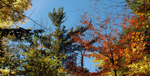
Snake Mountain reaches an elevation of 1,287 feet and stands as an island of upland forest in the agricultural heart of Vermont. Most of the WMA is covered in northern hardwoods, but other forest communities create a great diversity of plants and wildlife.

Informational signs  were installed along the Arthur Gibb Trail in 2020, during the COVID-19 Pandemic. Please be respectful of private landowners who allow use of their property.

Other Information

Wilmarth Woods - This Nature Conservancy preserve is one of the largest low-elevation, mature forest stands in the Champlain Valley. The soils here are deep and rich, and the mesic red oak-northern hardwood forest is one of the finest in western Vermont. Wilmarth Woods flanks the 1,215-acre Snake Mountain Wildlife Management Area. 

Snake Mountain WMA - The Vermont Fish and Wildlife Department began acquiring land for Snake Mountain WMA in 1959 from the A. Johnson Lumber Company. Funding was largely generated from the sale of hunting licenses, with recent acquisitions supported by the Vermont Housing and Conservation Board. Arthur Gibb donated 112 acres to the WMA as well. Today the WMA is 1,215 acres and protects eight rare plants and two known uncommon species, in addition to the views of the Champlain Valley and the Adirondacks from the 1,287-foot Snake Mountain summit.

Please note that the spur trail to the west is closed March 15 - August 15 to protect nesting peregrine falcons. 

Trail Manager

Wilmarth Woods and Snake Mountain WMA are managed in partnership between the Nature Conservancy in Vermont and the Vermont Department of Fish and Wildlife.

To learn more, visit The Nature Conservancy in Vermont or Vermont Fish and Wildlife online or contact:

Vermont Department of Fish & Wildlife - Wildlife Division, Lands and Habitat Program

Vermont Department of Fish & Wildlife - Wildlife Division, Lands and Habitat Program
Amy Alfieri
966 Route 17 West
Addison, VT 05491
Phone: 802-759-2398
Amy.Alfieri@vermont.gov
View website

The Nature Conservancy: Montpelier Office

The Nature Conservancy: Montpelier Office
Lynn McNamara
575 Stone Cutters Way
Montpelier, VT 05602
lmcnamara@tnc.org
View website

Trail Tips

Plan Ahead and Prepare
Find out about and follow any local regulations and respect landowners’ property.
Legend
Hide All

Trailhead Information

2514 Mountain Rd, Addison, VT

Travel south from Vergennes on Route 22A past the town of Addison. Turn left onto Wilmarth Road and follow to the end, then turn left again onto Mountain Road. There is a parking lot ¼ mile up on the left. The trail is across from Wilmarth Road.

Click on a parking icon to get custom directions
Please Log In or Create Account to add comments.
These awesome businesses support our goal of connecting people to outdoor adventures!
Hang Tight!
Nearby services are loading
No Results
No Services Found

Trail Alerts

Ecology
Annual Peregrine Closure
March 15 – August 15

These cliffs and surrounding areas are used by Peregrine Falcons, a state-listed endangered species, for nesting and rearing young fledglings. Peregrine falcons are very sensitive to disturbance near the nest site. To protect the peregrine chicks, certain areas are closed when the peregrines are nesting, generally from March through mid-August.

Trails
Private Property
This trail passes through private property. Please respect the landowner and protect future access by staying on the marked trail and following all rules.
Trails
Mud Season Trail Closure
March 11, 2024 – May 24, 2024

One or more trails in this system is currently closed due to muddy or wet conditions. Please help to protect our trails by not walking on them when they are soft and easily damaged. Learn more.

If any trails are open, they will be listed on the Details tab.

SHARE THIS TRAIL

Add Trail Log

Please wait…
Join In on the Fun!
Log in or create an account below to unlock all the great features of Trail Finder: keep track of trails you want to do, preserve memories of trails you’ve done, earn badges, and more!
Your log in attempt was not successful. Please try again.
    Lost your password? Reset your password
    Don't yet have an account?
    There was an issue with your submission. Please try again.
      * Indicates required field
      Already have an account? Login here
      Enter your username, and we will send you a new, randomly generated password to your email account.
      There was an issue with your submission. Please try again.

        Success! A new password has been emailed to you.

        Log in now

        Please wait…