Mud season is here!Protect the trails we all love by sticking to open, dry areas. Learn more! 

Mount Wantastiquet

Steep switchbacking trail to the flat summit of Mount Wantastiquet with sweeping views across the Connecticut River Valley.
Trail Activity
Hiking Snowshoeing
Length
4.60 miles, Network
Difficulty
Moderate
Towns
Chesterfield (NH), Hinsdale (NH)
Surface
Packed Earth/Dirt, Rock/Ledge
Pets
Permitted on leash
Fees
No

Description

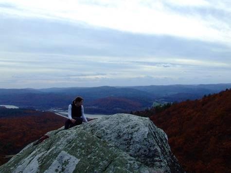
The Wantastiquet Mountain Trail begins between the two granite posts near the parking on the right side of Mountain Road. For most of its extent, the trail follows an old gravel road with many switchbacks. Side trails access a small waterfall near the trailhead and several viewpoints mid-mountain. After ascending 1,100 feet over 2 miles, the trail passes a rock outcrop with excellent views across the Connecticut River Valley. In another 0.1 miles, the trail passes near the true summit of Mount Wantastiquet at a clearing for the communication tower. Continuing east, hikers may access Mine Ledge Trail and then Ann Stokes Loop on the backside of Wantastiquet (not shown on map). A side trail descends due south along a gulch emerging onto NH-119 0.8-miles from the trailhead on Mountain Road.

The Lower Wantastiquet Trail is an easy walk along an old dirt road that provides many views as it parallels the Connecticut River. It is ideal for families and young children and is accessible to strollers. 

Trail Manager

Visit the New Hampshire Division of Forests & Lands online for more information, or contact:

New Hampshire Division of Forests & Lands

New Hampshire Division of Forests & Lands
172 Pembroke Road
Concord, NH 03301
Phone: (603) 271-2214
View website

Trail Tips

Plan Ahead and Prepare
Tell someone your plan and when you’ll return, just in case.
Legend
Hide All

Trailhead Information

From Brattleboro, VT: cross the Connecticut River on Bridge Street/NH-119/Brattleboro Road. Once on the NH side of the river, take an immediate left onto Mountain Road and travel 0.2-miles to the trailhead and parking area at the end of the road.

From Hinsdale, NH: travel west (north) on NH-119. Pass the Hinsdale Raceway and Walmart on the right and continue for 3 miles before taking a right on Mountain Road just before the bridge to VT. Travel 0.2 miles to the trailhead and parking area at the end of the road.

Click on a parking icon to get custom directions
Please Log In or Create Account to add comments.
These awesome businesses support our goal of connecting people to outdoor adventures!
Hang Tight!
Nearby services are loading
No Results
No Services Found
SHARE THIS TRAIL

Add Trail Log

Please wait…
Join In on the Fun!
Log in or create an account below to unlock all the great features of Trail Finder: keep track of trails you want to do, preserve memories of trails you’ve done, earn badges, and more!
Your log in attempt was not successful. Please try again.
    Lost your password? Reset your password
    Don't yet have an account?
    There was an issue with your submission. Please try again.
      * Indicates required field
      Already have an account? Login here
      Enter your username, and we will send you a new, randomly generated password to your email account.
      There was an issue with your submission. Please try again.

        Success! A new password has been emailed to you.

        Log in now

        Please wait…