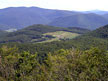
Mount Antone
Mount Antone is the tallest mountain on the property at 2,600 feet. It offers the most spectacular vista here at Merck—well worth the 5 mile round-trip hike which takes about 3-3½ hours round-trip depending on your pace and route. There are a number of different routes that can be taken to the summit. The most direct route would be to take Old Town Road to Antone Road and follow it up. For a longer hike, many visitors will take the McCormick Trail off of Old Town Road, through Clark's Clearing, to Antone Road and the summit. For experienced hikers looking for a challenge, from Route 315 in West Rupert turn onto East Street, make a left on Hidden Valley Road and follow it to the end to the back gate of Merck Forest. The trailhead from the Masters Mountain Trail can be found there. This trail is very steep and strenuous, with a total elevation gain of 1,600 feet via numerous switchbacks. Antone Mountain can be easily reached from our most popular cabins, Ned's Place and Nenorod, as well as from the Beebe Pond tent and lean-to sites.
Gallop Peak
"The Gallop" is the second tallest mountain on the property at 2,585 feet. The summit provides beautiful views of the Taconic mountains and beyond, especially in the winter. The hike to the top will take about 2½-3 hours round-trip, about 3 miles total. The best route to take is Old Town Road to Gallop Road, past the barn cabins and around the back of the peak. For an alternate route for your descent, take the Barton Trail and follow the signs to the lookout for another spectacular vista before descending to Lodge Road. Take a left on Lodge Road and follow until this becomes Old Town Road. Follow Old Town Road and this will take you back past the farm to the Visitor Center. Gallop road is fairly steep in one stretch and the Barton trail is very steep and not advisable for winter travel or ascending unless you are an avid hiker who is up to the challenge.
Wildlife Trail
This trail is one of two interpretive trails at Merck Forest. It offers interpretive signs discussing forestry management practices and their effects on area wildlife. In addition, this trail has two shortcuts so that you can really "choose your own adventure." This is a great trail to look for wildlife tracks, especially when snowshoeing in the winter. The trail starts as a spur off of the Discovery Trail, just below the sugarhouse. It can also be started by turning right off of Old Town Road just before our upper horse pasture or by taking the spur off of the McCormick Trail. If you choose to hike the trail in its entirety it will take about 2-2½ hours. If you are looking for a shorter hike of about a half hour, start from the Discovery Trail and take the first shortcut up to Old Town Road. There are a number of beautiful streams that run alongside the trail as well as a handful of old growth Birch trees.
Silviculture Trail
The Silviculture Trail is located about 1¼ miles off of Old Town Road from the Visitor Center. The trail itself is about 1 mile and ends at Birch Pond. It is an interpretive trail which strives to educate visitors about sustainable forestry practices. This mild trail has a series of educational signs as you pass through the different types of tree stands one might find in the Northern Taconic mountain range. This a great trail for families or anyone interested in learning more about the forest around them.
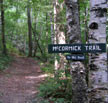
McCormick Trail
Named for a long-time friend of the Merck family, John McCormick was an amateur forestor and conservationist, who served on the Advisory Council and was extremely influential in advising Merck Forest on its forest programs. The McCormick trail splits off of Old Town road up to Clarks Clearing eventually connecting with Antone Road. It is a narrow trail and it is quite steep in portions. There are spectacular old red oak trees in Clarks Clearing and wonderful winter views to the northwest. It is a great loop when taken to Antone Road and then back to Old Town Road. A good alternative to taking Old Town Road all the way to the back end of the property. It is a narrow trail and it is quite steep in portions. As a loop this trail will take hikers about 1½-2 hours.
Stone Lot
Named after a farmer who previously farmed the plot where the trail ends, Stone Lot Road forks off of Old Town Road at the farm then travels through our vegetable fields before it dips down into the woods to the Stone Lot shelter. Your destination is a beautiful, secluded spot where a number of streams come together. The sound of the water trickling over the rocks is very relaxing. Stone Lot is often used by those looking for a less challenging walk. It has great views of the Green Mountains to the east and of the surrounding fields. Stone lot will take about 30-45 minutes round-trip to hike.
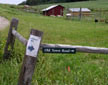
Old Town Road
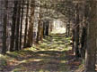
Old Town Road is the main artery of the property. It runs 4½ miles from the Visitor Center to our back gate in West Rupert. At its northern end, near the farm and Visitor's Center, it is Merck Forest's most heavily used trail. Once you get past Birch Pond, however, it receives relatively little use by hikers. The first stretch of Old Town Road, which leads to the farm, is a moderate hill. Then the road forks to the right and ascends a very steep hill. Once you have crested the hill by the Antone Road/Lodge Road fork, the road starts a fairly gradual descent down to the back edge of the property. After you pass Wade Lot Road and East Hollow Road it becomes fairly level and is more suited to cross country skiing. There are some spectacular views from the farm and across the upper horse pasture. There is also a great deal of beautiful stream scenery near the back gate of the property where the property line snakes along the headwaters of White Creek. The back gate is accessible from Hidden Valley Road in Rupert. From Route 315 in West Rupert turn onto East Street, make a left on Hidden Valley Road and follow it to the end to the back gate of Merck Forest. The back gate is also a good place to go for beginner's cross-country skiing.
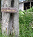
Discovery Trail
The Discovery trail is a short trail starting at the Visitor Center parking lot and looping downhill then up to the farm. The trail passes through some young forest, then through wildlife habitat cuts, then our orchard, ending alongside our horse pasture and sugar house. Hiking the discovery trail takes 20-30 minutes and it is a nice alternative way to get to the farm for those looking for something new. You can extend your hike by taking the connector trail to the Wildlife trail.
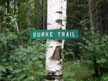
Burke Trail
Named for a former manager/caretaker at Wind Gap Farm, the Burke trail goes through mature, open woodland on a north facing slope. There is a mixture of birch, oak, maple, and other northern hardwood trees. The Burke trail gets little use in the summer, but it is a popular trail in winter for cross country skiers who enjoy skiing the fields near Rt. 315. Hiking the Burke Trail takes from 20 to 30 minutes. Halfway along the trail from either direction there is a nice view at the Fetterolf picnic area.
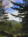
All of Merck Forest and Farmland Center's trails are open year-round for hiking, horseback riding, snowshoeing, and cross-country skiing. Our trail system, with over 30 miles of trails on 3,100 acres of land, is well-marked, and the trail terrain is variable: some loops cover easy-to-moderate terrain (great options for family treks), while other trails are steeper and rocky (more-suited to the experienced hiker). Many trails go through the forest, around the farm, travel along streams, and include beautiful views of the Taconic and Adirondack Mountains. Our Visitor Center is open daily from 9 a.m. to 4 p.m., and our staff is happy to provide you with trail recommendations.
Visit the Merck Forest & Farmland Center online for more information, or contact:
Merck Forest & Farmland CenterThe Merck Forest & Farmland Visitor Center is located at 3270 Route 315, Rupert, VT 05768. GPS coordinates: 43.28122,-73.169205. Click here for Google Map Directions.
Please check in and out at the kiosk located near the Visitor Center.
Success! A new password has been emailed to you.