The solar eclipse is coming on April 8th! Learn more about where you can go to view the eclipse and other useful tips.

Connecticut River Paddlers' Trail

The Connecticut River Paddlers’ Trail is a series of primitive campsites and river access points spanning 400 miles from the river’s headwaters to the Long Island Sound.
Trail Activity
Paddling
Length
276.20 miles, One Way
Difficulty
Easy, Moderate, Advanced, Strenuous
Towns
Barnet (VT), Bath (NH), Bloomfield (VT), Bradford (VT), Brattleboro (VT), Brunswick (VT), Canaan (VT), Charlestown (NH), Chesterfield (NH), Claremont (NH), Clarksville (NH), Colebrook (NH), Columbia (NH), Concord (VT), Cornish (NH), Dalton (NH), Dummerston (VT), Fairlee (VT), Guildhall (VT), Hanover (NH), Hartford (VT), Hartland (VT), Haverhill (NH), Hinsdale (NH), Lancaster (NH), Lebanon (NH), Lemington (VT), Littleton (NH), Lunenburg (VT), Lyme (NH), Maidstone (VT), Monroe (NH), Newbury (VT), Northumberland (NH), Norwich (VT), Orford (NH), Piermont (NH), Pittsburg (NH), Plainfield (NH), Putney (VT), Rockingham (VT), Ryegate (VT), Springfield (VT), Stewartstown (NH), Stratford (NH), Thetford (VT), Vernon (VT), Walpole (NH), Waterford (VT), Weathersfield (VT), Westminster (VT), Westmoreland (NH), Windsor (VT)
Surface
River/Stream, Lake/Pond
Pets
Permitted on leash
Fees
No

Description

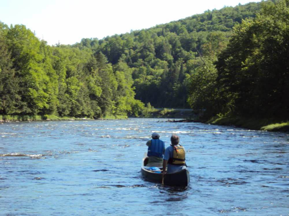
New England's longest waterway, the Connecticut River, provides over four hundred miles of canoe and kayak exploration. With its consistently navigable waters, few portages or difficult rapids, and a rich and varied landscape, the Connecticut River provides a unique opportunity to paddle through the heart of New England. 

The Connecticut River Paddlers' Trail is a series of primitive campsites and river access points spanning from the river's headwaters south to Long Island Sound. While most of the river shore is privately owned, a number of generous landowners have agreed to host the public at primitive campsites on their land. 

In the early 1990s, the Upper Valley Land Trust was instrumental in establishing formal river campsites in Vermont and New Hampshire. Since their initial effort, many others have developed additional campsites and completed access improvement projects throughout the watershed. The Friends of the Connecticut River Paddlers' Trail, a collaborative of partner organizations and community members formed in 2009 to work together in trail planning and development, building and maintaining campsites, improving access points and portage trails, and disseminating information to visitors. 

In 2012, through the leadership of the Appalachian Mountain Club, the Trust For Public Land, and the Silvio Conte Fish and Wildlife Refuge, an initiative to expand the trail south into Massachusetts and Connecticut was launched. The primary goal was to close the gaps in primitive campsite availability in MA and CT. The work to steward and expand the trail continues through this collaborative, which is now coordinated by a 7 person CRPT Executive Committee in partnership with members that represent state agencies, non-profit partners, and the general public.  

If you'd like to support this work, join the Friends of the Paddlers' Trail today! 

Purchase the official Map and Guide (VT and NH), and visit the Connecticut River Paddlers’ Trail website to learn more! In 2021 a new smartphone app and guide was released for the Paddlers’ Trail in partnership with FarOut Guides. Look for FarOut Guides in the app store of visit the web application here.  

River Etiquette

The future of the Paddlers’ Trail depends on good river etiquette and campsite stewardship. While most of the river shore is privately-owned, a number of generous landowners have agreed to host the public at primitive campsites on their land. Before heading out on the water, please review the trail’s paddler etiquette guidelines posted on the website and at many of the campsites. If you witness users disrespectful of these guidelines, please contact the appropriate site steward. Thank you! 

Other Information

FREQUENTLY ASKED QUESTIONS

How do I get a map?
A map which covers New Hampshire and Vermont, can be found online, at many local outdoor retailers, or by calling the NorthWoods Stewardship Center at 802-723-6551. The Connecticut Conservancy’s boating guide  is the best printed reference for the entire river and can be ordered from their website.  
 

In 2021 the CRPT Executive Committee released a Paddlers’ Trail Smartphone guide and  guide in partnership with FarOut Guides. It can be found in the App store, or by visiting the FarOut Webstore.    

Can I make a reservation?
    • Vermont and New Hampshire: Currently there is no reservation system in place for many of the primitive campsites. To see which campsites require fees and/or reservations visit the Paddlers’ Trail website or download the FarOut smartphone guide. All campsites are first come-first served, but paddlers are encouraged to post their intent to stay on the registration calendar so that other paddlers can plan accordingly.  
    • Some campsites might be closed due to maintenance, abuse from users, or for the winter. Before embarking on your trip, it is best to check the campsite status page at www.connecticutriverpaddlerstrail.org
    • Massachusetts and Connecticut: Reservations are required for some existing sites in Massachusetts and Connecticut. You can find more information about MA and CT sites HERE.  

How big are the campsites? How many people can stay at the campsites?
Generally, the maximum group size at a river campsite is twelve people or 3 tents. However, many campsites are only suited for smaller groups. Check the list of campsites as you plan your trip. Please limit your stay to no more than two nights per site. If the campsite is full and you must find another place to camp for the night, request permission from the landowner. Parties of 10 or less will avoid special use permit requirements from the State of VT.

Is the trail complete?
No. Currently there are still a few gaps in the trail, the largest being an 27 mile gap in campsites between Longmeadow, MA, and Cromwell, Connecticut. Trail partners are working to develop new campsites to close this gapHelp support this effort! 

Who takes care of the campsites?
Each campsite, access point, and portage trail has a designated site steward charged with annual maintenance. Many organizations rely on volunteer site adopters  to complete annual monitoring and maintenance tasks. 


Trail Manager

Work to steward and expand the Connecticut River Paddlers’ Trail is coordinated in partnership by a seven person CRPT Executive Committee with members that represent state agencies, non-profit partners, and the general public. Visit the Connecticut River Paddlers' Trail  for more information or reach out to the Vermont River Conservancy for stewardship questions and the Connecticut River Conservamcy for general inquiries, map orders or app questions using the contact information below.  

Connecticut River Conservancy

Connecticut River Conservancy
15 Bank Row
Greenfield, MA 01301
info@ctriver.org
View website

Vermont River Conservancy

Vermont River Conservancy
29 Main Street, Suite 11
Montpelier, Vermont 05602
noah@vermontriverconservancy.org
View website

Trail Tips

Be Considerate of Other Visitors
Be aware of and limit the noise you and your group generate. Enjoy the sounds of nature.
Legend
Hide All

Trailhead Information

Connecticut River access points within the states of VT and NH are depicted on Trail Finder's interactive map; access points have parking available.

If you are planning to head out on the river, consider purchasing the official waterproof Map and Guide for VT and NH, The Connecticut River Boating Guide, or downloading the FarOut Smartphone App 

Click on a parking icon to get custom directions
Please Log In or Create Account to add comments.
These awesome businesses support our goal of connecting people to outdoor adventures!
Hang Tight!
Nearby services are loading
No Results
No Services Found

Trail Alerts

Safety
Be a Safe and Respectful Paddler
Paddling conditions will vary according to the weather and season, so always exercise caution and always wear a lifejacket. With good judgment and proper equipment, the risk associated with paddling can me minimized. Respect the natural world and the rights of landowners, and be considerate of other outdoor enthusiasts. Paddlers should seek to avoid causing erosion, trampling vegetation, disturbing wildlife, and harming water quality.
SHARE THIS TRAIL

Add Trail Log

Please wait…
Join In on the Fun!
Log in or create an account below to unlock all the great features of Trail Finder: keep track of trails you want to do, preserve memories of trails you’ve done, earn badges, and more!
Your log in attempt was not successful. Please try again.
    Lost your password? Reset your password
    Don't yet have an account?
    There was an issue with your submission. Please try again.
      * Indicates required field
      Already have an account? Login here
      Enter your username, and we will send you a new, randomly generated password to your email account.
      There was an issue with your submission. Please try again.

        Success! A new password has been emailed to you.

        Log in now

        Please wait…