Mud season is here!Protect the trails we all love by sticking to open, dry areas. Learn more! 

Butternut Hill Natural Area

Take a stroll through floodplain/cedar pine forest to a great southerly view of Lake Champlain.
Trail Activity
Hiking
Length
0.80 miles, One Way
Difficulty
Easy
Town
North Hero (VT)
Surface
Packed Earth/Dirt
Pets
Not Permitted
Fees
No
Other Activities
Hiking

Description

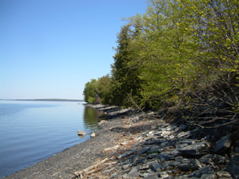
The mile long trail at Butternut Hill winds through floodplain forests, cedar pine forest and cobble shorelines while offering a great southerly view of Lake Champlain. There is a beautiful walk out to a point of land overlooking the water and two nice shale beaches that someday could support nesting soft-shell turtles.  Portions of the trail are flooded and impassible when the lake level is higher than 97 feet.  Check lake levels before you head out at http://www.weather.gov/btv/recreation.  

Other Information

Butternut Hill Natural Area was conserved in partnership with the Lake Champlain Land Trust and consists of approximately 77 acres of a mix of wetlands, uplands, two small agricultural fields, and over 500ft of undeveloped Lake Champlain shoreline. The two wetlands are both long, narrow branches of Lakeside Floodplain Forest divided by a low, forested ridge with a beech forest containing impressively large trees and a small patch of red cedar woodland along the rocky bluff at the lake shore.

Trail Manager

Visit The Nature Conservancy in Vermont online for more information or contact Lynn McNamara, Critical Lands Manager for Northern VT:

The Nature Conservancy: Montpelier Office

The Nature Conservancy: Montpelier Office
Lynn McNamara
575 Stone Cutters Way
Montpelier, VT 05602
lmcnamara@tnc.org
View website

Trail Tips

Dispose of Waste Properly
Pack it in, pack it out. This goes for trash, leftover food, toilet paper, and hygiene products. If you brought it into nature, please bring it out.
Legend
Hide All

Trailhead Information

1769 South End Road, North Hero

From the South: Take I-89 N to exit 17 for US-2 toward US-7/Lake Champlain Islands/Milton. Keep right at the fork and merge onto US-2 W/Roosevelt Hwy. Continue to follow US-2 W 18.9 miles. Turn left onto South End Rd and follow for about 1.8 miles. Camp Ingalls (Butternut Hill Natural Area parking) will be on the left.  Walk in along the trail behind the camp buildings.

From northern New York: Take US-2 E for 20.8 miles. Turn right onto South End Rd and follow for about 1.8 miles. Camp Ingalls (Butternut Hill Natural Area parking) will be on the left.

Click on a parking icon to get custom directions
Please Log In or Create Account to add comments.
These awesome businesses support our goal of connecting people to outdoor adventures!
Hang Tight!
Nearby services are loading
No Results
No Services Found
SHARE THIS TRAIL

Add Trail Log

Please wait…
Join In on the Fun!
Log in or create an account below to unlock all the great features of Trail Finder: keep track of trails you want to do, preserve memories of trails you’ve done, earn badges, and more!
Your log in attempt was not successful. Please try again.
    Lost your password? Reset your password
    Don't yet have an account?
    There was an issue with your submission. Please try again.
      * Indicates required field
      Already have an account? Login here
      Enter your username, and we will send you a new, randomly generated password to your email account.
      There was an issue with your submission. Please try again.

        Success! A new password has been emailed to you.

        Log in now

        Please wait…