Bonnyvale Environmental Education Center has 2.3 miles of trails that are open for walking from dawn until dusk. Interpretive guides are available to make your walk informative. The trails feature some very large old sugar maples, an abundance of spring ephemeral wildflowers, and the sweeping view from Heifer Hill. Dogs on leashes are welcome; please clean up after your dog to keep the land welcoming for everyone. Hunting is not allowed at BEEC, but we recommend that people and dogs wear blaze orange during hunting seasons, especially if walking early or late in the day.
Dorothea’s Way, 1 mile loop, the primary trail from which all others diverge
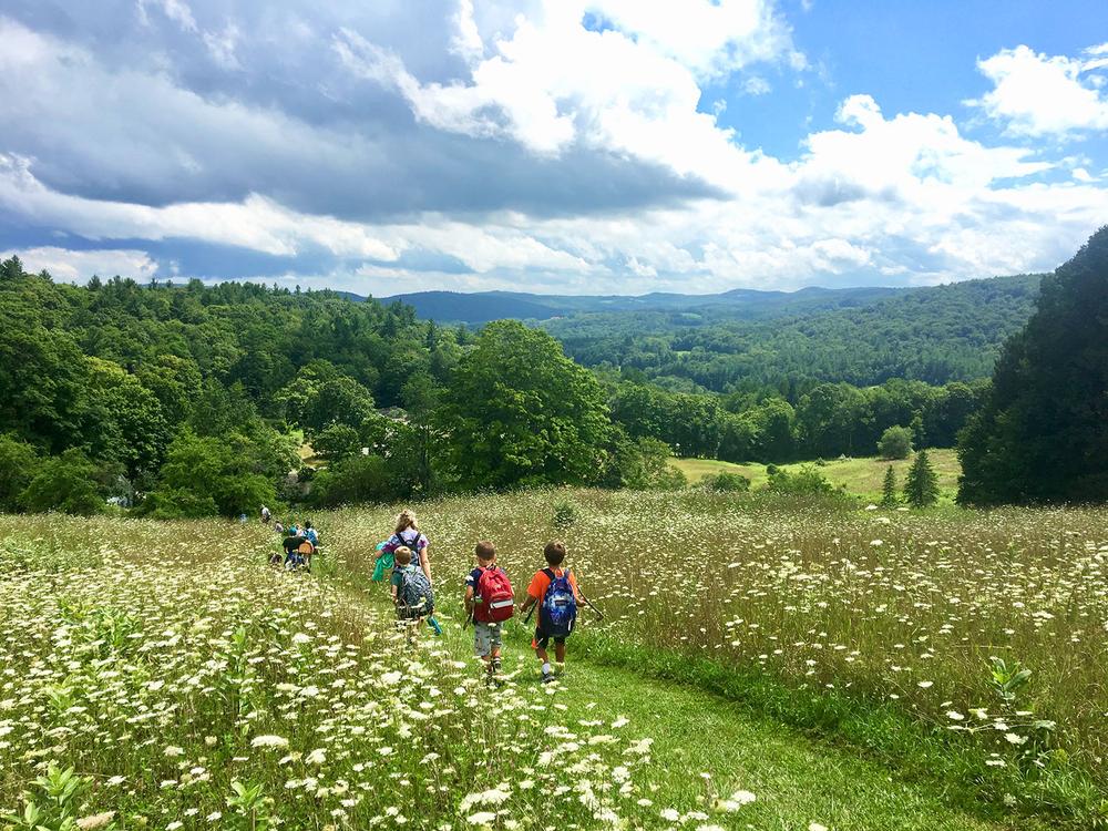
Named in memory of Dorothea Stockwell, a founder of BEEC, this trail winds through a diverse forest of young and old hardwoods and conifers. After crossing the south pasture, the trail enters the woods where it descends gradually through a hemlock forest. Listen for the wood thrush’s beautiful song in the early evenings of summer. The stairlike ledges seen throughout this area are ideal habitat for fisher and other small mammals. Dorothea’s Way climbs a series of steep but short slopes, leading to the western-most boundary of BEEC. As the trail levels out and heads in a southeasterly direction, the forest landscape changes abruptly. Slender maple trees are key indicators of an early successional forest. Formerly known as the “Night Pasture,” this area along Dorothea’s Way was once a field. The trail finally opens to reveal a panoramic view at the summit of Heifer Hill, where Vermont’s Round Mountain and Ginseng Hill to the northeast and New Hampshire’s Wantastiquet and Monadnock Mountains to the east can be seen on clear days. The nearby hills of the Sweet Pond Road area of Guilford are visible to the south. The final steep decent along Dorothea’s Way leads back to BEEC’s courtyard area.
Upperway Maple Trail, 0.3 miles
The Upperway Maple Trail connects at either end to Dorothea’s Way. This meandering ridgetop trail is named for the many large sugar maple trees found here. This area was formerly part of the “Night Pasture.” Their age is estimated to be 300 years, about the maximum age for sugar maples. The trail also passes through a sugar maple-hophornbeam savannah, a park-like forest with a “lawn” of sedges.
During summer months, look for the small wood frogs that abound on the forest floor.
Barred Owl Trail, 0.15 miles
This short trail connects Dorothea’s Way and the Upperway Maple Trail. If you are looking for a short walk, the Barred Owl trail is part of a nice loop. Large, rounded calcareous schist boulders are found along the Barred Owl Trail. Covered in moss, these rocks offer important clues to Heifer Hill’s geologic past. The highlight of this trail is the impressive maple that stands on the rise at the end of the trail. Especially spectacular in moonlight, Grandmother Tree seems to be the stalwart guardian of the forest. If you follow the Upperway Maple Trail past the other side of this tree, you will see that it is a living shell, with a hollow large enough to accommodate a pile of porcupines.
Deer Run, 0.9 mile loop
From the summit of Heifer Hill, this trail takes hikers down into the North Hollow, where unusually rich soils nourish a thriving forest community. Along the trail you might find plants that are eco-indicators of moist, rich soils, such as maidenhair fern, blue cohosh, Jack-in the-pulpit, miterwort, and trout lily. Bitternut hickories, indicators of soil richness, grow tall and straight along this trail.
The lush understory of this forest provides food and shelter for deer. If you sit quietly along this trail, you will be able to observe some of the many birds and mammals that live here.
Deb’s Trail, 0.25 miles
Created in memory of beloved BEEC educator, Deb Smith, this trail begins in a cove of rich, moist forest and climbs gradually up to the drier hilltop. Many interesting rich soil plants can be found along this trail including maidenhair fern, Goldie’s fern, and in season, spring flowers like dutchman’s breeches, hepatica, and blue cohosh.
This trail also passes among large pits and mounds created when a hurricane toppled big trees long ago. The standing stones you will see were tipped up by the roots as the trees fell.
Enjoy a rest on Deb’s bench at the top of the hill.
Bonnyvale Environmental Education Center is a member-based, nonprofit organization, founded in 1991 to foster experiences that inspire connection to the natural world and its many inhabitants. BEEC offers a wide variety of environmental programs to adults and children of all ages, including:
![]()
Location: 1223 Bonnyvale Road, West Brattleboro, Vermont
From Exit 2 off Interstate 91, take Route 9 (Western Avenue) west 1.2 miles. Bonnyvale Road will be on the left. Take Bonnyvale Road 2.2 miles. When you go over the crest of a very steep hill (Danny’s Nub), look for the BEEC sign in front of a white farmhouse. Please park in the parking area below the BEEC sign.
Success! A new password has been emailed to you.