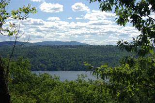
Bunker Loop Trail
The Bunker Look Trail may be reached via the Pingree Connector from the parking area (P) on Pingree Road. The Bunker Loop Trail intersects with Cocoa’s Path (also known as part of the Great Brook Trail and the SRKG). To make a loop, bear left when you reach the Bunker Loop Trail. The trail proceeds uphill under the powerline then continues more steeply until it levels out and turns right onto an old woods road. Continue on the level then bearing to the right when you have a choice to an intersection with the Wolf Tree Trail (SRKG). Continue downhill on the Wolf Tree Trail to Cocoa’s Path then walking back along the brook to the Bunker Loop Trail. Access to Cocoa’s Path and the Wolf Tree Trail can also be made from the parking area (P) on Lakeshore Road. The full loop is 1.78 miles; the trail from Pingree Road via the Pingree Conector, south on Cocoa’s Path to the Lakeshore Drive Trailhead is 0.63 miles.
Cocoa's Path Trail
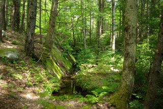
Cocoa’s Path is a section of the Great Brook Trail between the bridge above the Lower Cascades and the start at Lakeshore Road. Cocoa's Path follows the east side of Great Brook and can form a loop by using the Pingree Connector to Pingree Road. The Great Brook Trail is part of the Sunapee Ragged Kearsarge Greenway (SRKG) which continues on into Springfield or up the Wolf Tree Trail. Two access points with parking (P) are at Lakeshore Drive and Pingree Road, as shown on the map. The trail may be combined with the Bunker Loop and Wolf Tree trails to provide loop hikes.
Cook Interpretive Loop Trail
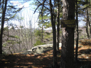
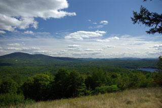
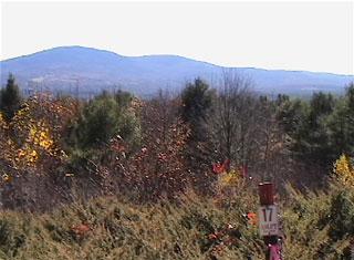
The Cook Interpretive Loop Trail (pink flagged) is 1.1 miles and starts at the parking area (P) along Whitney Brook Road where the Ausbon Sargent Land Preservation Trust (ASLPT) sign #49 is visible from the road near the power line crossing. The trail's highest elevation provides views of Ragged, Kearsarge, and Sunapee Mountains. Interpretive fliers that describe the trees, shrubs and geological features along the Cook Interpretive Loop Trail are available at the trail head. The numbers on the ASLPT signs are keyed to the flier.
This trailhead also leads to the Pleasant Lake High Trail. There are several other possible Cook loop trails (flagged in blue, green, yellow, or orange but not shown).
Langenau Forest Trail
The Langenau Forest Trail in Wilmot starts at the parking area (P) along Messer Road (right turn from Granite Hill Road at the top of the hill). The trail passes through a gate in 0.15 miles (the gate is the actual trail head with a sign). The trail passes an active beaver pond, ascends 130 feet, then descends 300 feet to its junction with the Webb Forest Interpretive Trail and the Wolf Tree Trail (SRKG) at the New London - Wilmot town line. The trail is 1.03 miles long.
Pleasant Lake High Trail
The Pleasant Lake High Trail starts at Whitney Brook Road along with the Cook Interpretive Loop Trail, which is marked with pink flags. The trail ascends following several other flag-marked trails on the Cook property. The Pleasant Lake High Trail is blazed with a combination of an orange trapezoid and green circles. Shortly after passing over the mountain view point marked 17, the High Trail branches to the left from the Cook Interpretive Loop Trail. The Pleasant Lake High Trail ascends about 90 feet, then descends 170 feet to Deming Pond. Next the trail ascends 480 feet in 0.7 miles to its highest point near the New London - Wilmot town line. It follows along the town line descending 200 feet in 0.9 miles to the Webb Forest Interpretive Trail just below the intersection with the Wolf Tree Trail (SRKG). The trail is 2.56 miles long. This trail, when combined with the Langenau Forest Spur Trail, provide a one-way hike of 3.6 miles between the Whitney Brook and Messer Road parking areas.
Webb Forest Interpretive Trail
This trail through the 2,000 acre Webb Forest provides guide sheets describing the beneficial long-term forestry practices identified by signs along the trail. An interpretive brochure is available at the entrance to the Wolf Tree Trail.
The Webb Forest Interpretive Trail starts at the southern intersection with the Wolf Tree Trail (SRKG) about 1/4 mile from Lakeshore Drive, then proceeds over to a knob with a view, crosses a woods road, then Sargent Brook and climbs 350 feet to a second intersection with the Wolf Tree Trail at the Wilmot - New London town line. At this point, the trail becomes part of the SRKG in Wilmot and continues to climb another 220 feet when it separates from the Greenway. The trail continues west then descends 300 feet to its terminus again on the Wolf Tree Trail. Several loops can be made in combination with the Wolf Tree Trail. The complete trail is 2.6 miles in length and a loop from the parking lot on Lakeshore Road (P) using the Wolf Tree Trail adds another 0.6 miles.
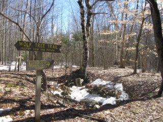
Wolf Tree Trail
This trail is named for the unusually large crowned "wolf trees" standing in the largely second-growth forest that dominate their environment. An interpretive brochure is available at the entrance to the Wolf Tree Trail.
The Wolf Tree Trail (also named the SRKG) starts at the parking area (P) on Lakeshore Road, stays straight when it intersects with the Great Brook Trail which goes off to the left (SRKG, also known here as Cocoa's Path). The Wolf Tree Trail proceeds uphill to the intersection with the Webb Forest Trail (which goes off to the right), then to the intersection with the Bunker Loop Trail (going to the left), and to the other end of the Webb Forest Trail (going left). When it reaches the connector trail, the Wolf Tree Trail bears sharply right, then rungs along the Wilmot, New London town line to terminate at the Webb Forest Trail. Several loops can be made using the Bunker Loop Trail and the Great Brook Trail or in combination with sections of the Webb Forest Trail. The trail extends 1.6 miles.
Sunapee Ragged Kearsarge Greenway (SRKG) Trails 6
This section of the SRKG, following the Wolf Tree Trail and parts of the Webb Forest Interpretive Trail. It is a mixture of well-developed wooded paths and woods logging roads, with two uphill sections. The SRKG is clearly marked by white trapezoids, including where it follows portions of New London Conservation Commission Trails, which have their own round red blazes.
For more complete trail information, visit New London's Conservation Commission or Sunapee Ragged Kearsarge Greenway, or contact:
New London Conservation CommissionTrailhead on Route 4A: SRKG
From center of Wilmot, NH, travel east on NH Route 4A for about two miles. Turn left on to School House Road and trailhead parking area will be on your left.
Messer Road: Langenau Forest Spur
From center of Wilmot, NH, travel west on NH Route 4A. After about a half of a mile, turn left onto Granite Hill Road. Follow Granite Hill Road for a mile until it turns right and becomes Messer Road. Follow Messer Road until it ends and trailhead parking will be on your right and left.
Whitney Brook Road: Cook Interpretive Loop, and Pleasant Lake High Trail.
From Elkins, NH, head northeast on Wilmot Center Road. After about two thirds of a mile, turn left onto Whitney Brook Road. Continue on Whitney Brook Road for about a half of a mile and the trailhead parking will be on your left.
Lakeshore Drive: Cocoa's Path and Wolf Tree Trail.
From New London, head northeast for 0.7 miles on Pleasant Street. Pleasant Street will turn slightly to the right and become Lake Shore Drive. Continue on Lake Shore Drive until you see the trailhead parking on your right.
Pingree Road. Direct access to Pingree Connector Trail, and then Cocoa's Path and Bunker Loop Trail.
From New London, NH, head northeast for 0.7 miles on Pleasant Street. Turn slightly left onto Pingree Road. After about 0.3 miles you will see parking on your left and the trailhead on your right.
Success! A new password has been emailed to you.
